Valley Nervia walking, trekking, cycling and swimming
Walking
We think that our valley is attracting many more walkers. Perhaps the Covid pandemic has made people more health concious and inclined to avoid crowds. Since there were no known cases locally, and our hotels and restaurants want to remain that way, Valley Nervia is a healthy place to enjoy the outdoors.
Detailed maps for walkers can be bought in the station at Ventimiglia and in the main bookshop in the town. Google maps are always a helpful guide and there is quite a bit of additional information about the local mountains on the web (put any of their names into Google). Since I began to introduce the Valley Nervia to English speakers, walking has become more popular and much better signed and resourced. People in Italy have a right to roam but walkers should take care when crossing people’s property and gardens. If owners are present it is only polite to ask permission ‘permesso ?’.
The European Union, ‘Alps without Frontiers’ project has improved access to the border region for walkers. Paths have been cleared, maps and walking guides produced, places to stay registered and refugio restored. Europe has also funded the continuos promenade for cycling and walking all along the coast. Two long sections are now completed. Going east, the Ospidaletti to San Lorenzo portion goes for 18 km using the now converted railway line, the western part, Bordighera to the French border is along the renovated promenade.The bridge over the Nervia at Comporosso is now complete. The whole has been beautifully landscaped with water and refreshment points along the way.
Great variety
Take a stroll around the village, walk the old mule tracks and hill paths or climb up into the mountains. Enjoy the sea coast, woods, vineyards and olive groves on foot. There is immediate access to the surrounding hillsides from the village of Apricale and so much choice if you want to explore further.
Between hilltop villages
Trekking between hilltop villages makes a lovely day out. There are paths from Apricale to Baiardo, Apricale to Perinaldo, Baiardo to Castelvittorio, Rocchetta to Isolabona or Perinaldo to Dolceacqua. You can choose to picnic and rest in a shady olive grove or chestnut wood at midday or sit down to lunch in a village trattoria. All of the hilltop villages have a choice of café/bars for snacks, meals, wine, cold beer or coffee.
Ancient mule tracks
The ancient footpaths which snake their way through the wooded valleys and up and around the terraced hillsides are great walking routes. Most of these are old mule tracks, which were once the only paths linking villages, family lands and churches. We have found that some of the tracks marked on maps have become a bit overgrown but most are still passable and with more people walking things are improving. The hills around Apricale are all accessible, some pathways reach tremendous heights above the Valley Nervia, giving spectacular views. In addition to mule paths, there are many quiet tarred roads which are suitable for walking and biking and dirt tracks which are used by local farmers to access their vineyards and olive groves. All of these are marked on local maps.
Rights of way markers
You have a right to roam in Italy although some (mostly incomers) do not respect this. In addition footpaths are shown by different coloured markers, red and white, yellow, blue, and green. The colours refer to paths in the various European networks, rather than the level of difficulty. Most of the marked tracks around Apricale are part of the European Via Alta system, which connects countries, national parks and nature reserves across this part of Europe. Average completion times and difficulty are sometimes marked on the signposts. Some have markers showing T for tourists, E for trekkers, EE for expert trekkers (experienced on rough tracks, mountain weather, steep slopes) and EEA for the fully equipped climber.
Village walks
The Panoramic route
Why not start with a panoramic tour around Apricale, a chance to view the village from all angles. Follow the bus route up and beyond the cafe Apricus and branch to the left on the road to Biardo. Pass by the left turn to the village cemetery, (worth a visit because it displays family names, little photographs and sometimes the trades of those interned there) and take the next left which passes above the village. From here it is possible to look own into the square. Keep going past the little church of Saint Rocco,on the left, built in 1576. St Rocco was thought to cure the plague (which devastated Liguria in the 6th century and regularly returned) and is pictured in the traditional way, showing a wound on his leg. Keep to the road around the sharp bend and pass by a right hand fork to Vernunte. As you continue beyond the Vernunte track take in the marvellous views of the village on your left below. At the junction, after about a kilometre, head down to the left towards La Favorita Ristorante, which serves a very good traditional lunch. The route continues back towards the village to meet the main road again. After a hundred yards or so step down from the road to your right to view the wells which were once thought miraculous and pass by the church Santa Maria degli Angeli, the oldest church in the village which was built sometime in the 1200s. This cobbled way is the original road into Apricale. Regain the main road where it curls around the foot of the village.
There are a number of points along this panoramic route where it is possible to climb down into or up from the village centre. To do the whole walk around the village will take almost two hours but you can obviously do it section by section.
Wheelchair Users. For wheelchair users able to be transported by car there are parking places. The middle section of the panoramic route is almost traffic free and flat with some magnificent views.
A short route to Isolabona
On your way back down, not long after the TEATRO sign painted on the road, at the first hare pin bend distinguished by a massive water tank above the road, straight ahead is a quick decent down to Isolabona. Take care, one short section of this path is a bit rough.
Walking the road to Biardo
Rather than curling around the village, it is possible to walk straight on towards Baiardo using the main road which is never very busy. This has some beautiful views, a little church to visit and takes 3 hours or so if you are reasonably fit. The last section climbing up into Biardo is steep. The ruined church with its tragic history and panoramic views over the whole area are well worth the climb up.
Exploring the Vernute track
Allow at least two hours. Start at the very top the village, turn left on the panoramic route above the village and head past the little church of St Rocco on the left. Continue onwards to the sharp bend and turn right here up the steep little road marked Vernunte. This will lead to some higher tracks with tremendous views over Apricale and Isolabona. To find these climb quite steeply for a couple of hundred metres. You can pick blackberries in the ravine on your right in late summer. Turn sharp left through pretty olive groves and quite quickly the track levels off. Follow the contours around the hill keeping to the left when you meet any fork in the way. If you want to explore the tracks going up to the right they will eventually take you to the Apricale to Biardo Road. If you ignore all these and keep left on the stoney track around the hill, you eventually come to a righthand bend going over the ridge.
This swing right over the brow of the hill descends down to Strade San Pietro. This is the far end of the road up the hillside as you approach Apricale from Isolabona, which is signposted for Favorita restaurant. As you descend the view changes, you should begin to see down into the valley Nervia and be rewarded with great views of Monte Toraggio in front of you. At the bottom of this track a turn left onto Strada San Pietro will take you back through lovely olive groves and eventually the point where the road forks and where you will see TEATRO marked. A left turn here will take you back to the village on the panoramic route with interesting views of the village all the way. You should eventually pass the little church of St Rocco again and return to the point above the village from which you started. A right turn at the TEATRO point will take you down quite steeply past La Favorita Ristorante to the main provincial road and the wells below the village close to the little church of Santa Maria degli Angeli. We have often walked over this Venunte route in the moonlight, which is magical !
Exploring the path to Perinaldo
A two hour tour. On the other side of the village try the lovely but strenuous walk from Apricale up to Perinaldo via the track which crosses the little, old, arched bridge below café Apricus. Beside this hump backed bridge over the river Mandancio in the valley below the village, you pass the ruined oil mill which was built by the people of Apricale in order to escape the payment of ten per cent milling tax collected by Emperor Napoleon. The track starts opposite the old folks home, just before the farmacia, alongside the ridiculous building cantilevered out from the wall. Once across the river via the arched bridge a turn left will take you to the road between Apricale and Perinaldo via the church in the woods. This shorter, circular walk takes two hours or more to complete. About a third of the way up the hill, look for a turn to the left towards the church of Our Lady of Modina, which is hidden in the chestnut trees. Then continue beyond the church until you meet the Perinaldo road from whence take a left back round to Apricale. A little higher up on this Perinaldo road, there is a little headstone commemorating the death of an Apricale (partisan) man killed by German soldiers during the war. The little shrine was still tended until quite recently.
Continue straight on up the cobbled, former mule track, you will eventually emerge at the top of the hill from where you can climb up some steep steps directly into Perinaldo.
A full day hike.For a much longer alternative, (a full day’s hike) swing to the right on the road below Perinaldo. When you reach the road junction on the brow of the hill, with views down to the coast, take a right turn and enjoy the level, quiet road along the ridge towards Dolceacqua. Follow the signs for the agriturismo, which point right at the first fork in the road. If you keep going, the road winds along the hilltop before swinging left on the brow of the hill and down to the agriturismo. Beyond the entrance to this agriturismo you will see the stations of the cross on both sides of the road leading down to the little church looking over the Nervia valley. If you keep straight ahead and leave the road just below the church you can find a second set of stations and a steep track down to the castle and old town of Dolceacqua.
The agriturismo La Locanda degli Ulivi is mentioned in detail elsewhere on this website. This is signposted to the left before you get to the stations and the church. This walk with lunch (must be booked at weekends) makes a wonderful day out. Check the bus timetable for your return to Apricale.
Wheelchair Users. Drive up to Perinaldo, turn right at the top and park your car a little beyond the signs for the agriturismo. There is then a good level section of road which runs for a few kilometres along the ridge towards Dolceacqua with marvellous views of Apricale and rarely any traffic.
Strada San Pietro
Strada San Pietro comes up past the Favorita, meets the panoramic route and continues to the left. It opens out above the old monastery, with magnificent views of the mountains and ends in three smaller tracks. You will find the remains of the old monastery if you look out for a small sign pointing down to the left at the point where there is an open and dramatic view of the mountain. The land around this track is the original site of the village of Apricale. The monastery ruins can be found a few hundred yards down the track, hidden in the trees on the right, at the back of the grassy space used for the San Pietro Festa at the end of June.
Strada San Pietro continues straight on before dividing into three tracks. The lower one runs down steeply and is local to San Pietro. The middle one becomes a rough and overgrown path. The upper one continues for several miles through overgrown chestnut groves, deserted rustic houses, wells and streams. These are great places for funghi hunting in autumn and shady walking in summer. From this track you can pick up the Via Alta system above Apricale and descend into the village. At the end of Strada San Pietro is Piedmontese Mario’s land and rustic home. Call ‘permesso’, ‘permit me’ as you cross, if he is home he will happily show you the way to find the route.
Biardo to Castel Vittorio.
The road between Biardo and Castel Vittorio is quiet and pleasant for walking. There are some great views of both villages and also down the valley to the coast. Both centres have good restaurants. Consult the timetable for buses to Castel Vittorio. If you are walking from the bus stop the first part of the road up onto the ridge is steep!
Wheelchair Users. From Castel Vittorio the road up towards Biardo is very steep and winding. But a section of the ridge is quite level and almost traffic free with lovely views. It would be easy to find a place to park and for a wheelchair user to enjoy a few kilometres of woodland, wild flowers and valley views.
Exploring Valle Gordale
At the top of the Valle Nervia, is the valley Gordale (keep straight on at the sharp bend on the bus route up to Castel Vittorio). This is a mostly shaded valley, with river swimming and dipping available along the way. A circuit is possible if you use the first hundred yards of the Colle Langan road to cross the river Gordale. Arriving by car you can park here. Take one of several tracks off the road to the right. The first one begins with a little set of steps up from the road but there are others. Follow the valley up and up until you find the unmade road/track which passes below Palazzo del Maggiore and continues down quite steeply to the river crossing at Casa Castagnole. From here it is possible to return on the little used tarred road close to the river Gordale, back to the sharp bend on the road to Castel Vittorio, mentioned above, and thence back down the valley to your starting point.
The Alta Via footpath, walking in and above the Valley Nervia.
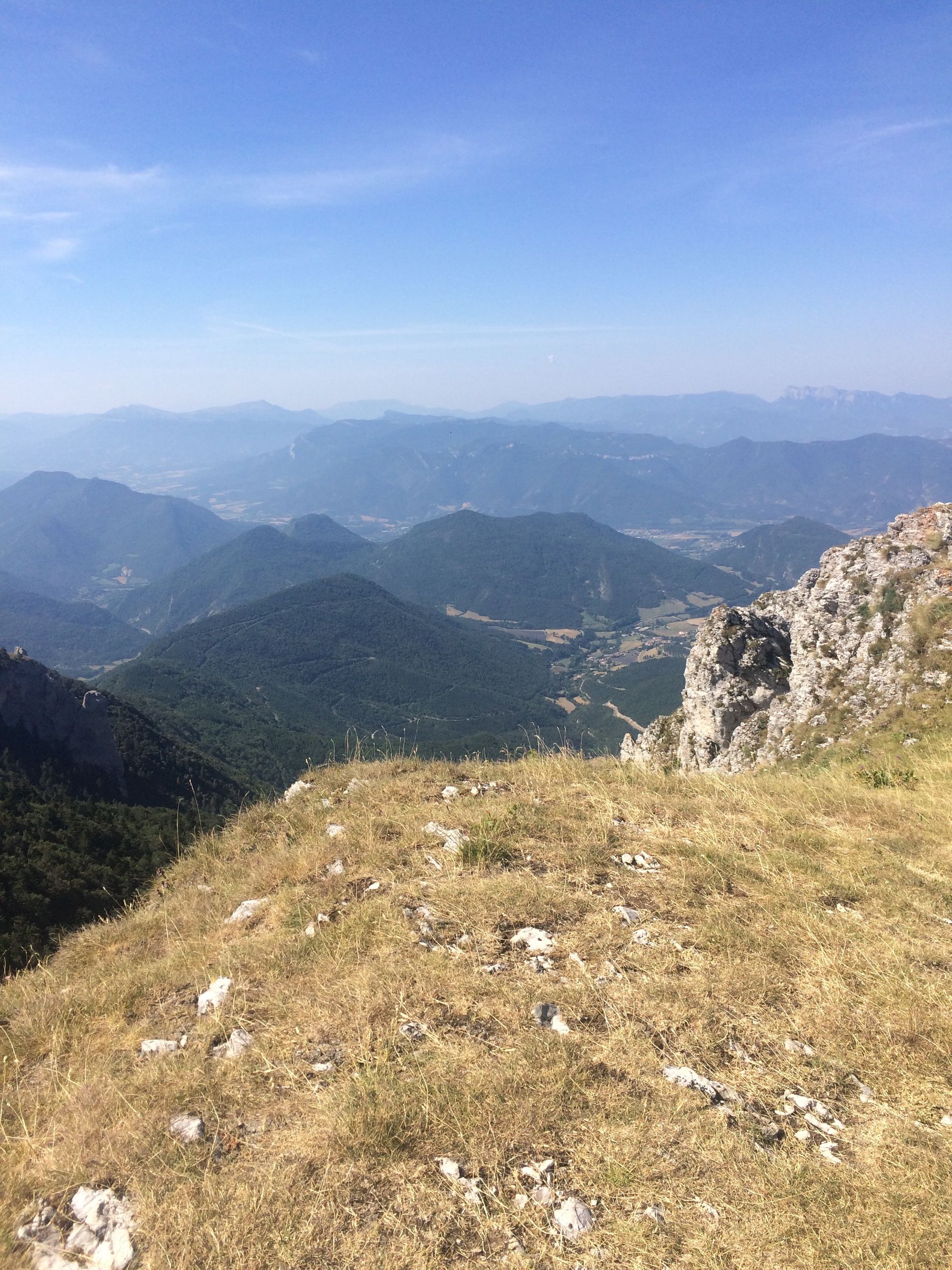
The Alta Via dei Monti Liguri is a scenic, hilltop hiking route which runs along the Ligurian mountaintops from Ventimiglia to the Tuscany border. It covers over 400 kilometres. From the Alta Via walkers can view the mediterranean in one direction or the Alps in the other. The many, many pathways which make up the system are marked and fully sign-posted in red-white-red and/or the letters AV. Throughout the Ligurian hills there are paths which join or leave the main hilltop route. You may choose to walk for several days or just a few hours.The footpath, winds it’s way across Liguria from Ventimiglia to Imperia, taking in the major peaks, (Mount Scarassan mt 1275, Mount Toraggio mt 1971, Mount Petria Vecchia mt 2038 and Monte Grai mt 2013). There are various places along Valley Nervia were you can access the Alta Via. Long ago, fish and salt from the coast and cheese from the slopes of Monte Toraggio would have been traded along the mule paths which make up the route. Local paths join longer trails which cross the mountains from France to Italy. These old trading routes also provided connections between the French and Italian resistance during World War II. Some parts were heavily fortified for troop movements and border control such as the route up to Gouta, the slopes of Monte Grai and the area around Colla Melosa. For more information on the path and some clear route maps go to :http://www.altaviadeimontiliguri.it .
Finding the Alta Via above Ventimiglia
To explore the first few miles of the Alta Via walk park in the long term car park at Ventimiglia station or get off the bus near the station. Cross the railway by the modern road bridge and check the map and signs on the far side of the road. Notice the red and white stripes which mark the way on fences, rocks and walls. The first few hundred yards of the walk are on a steep road between houses, the next few are a bit of a scramble in places as you climb steeply up above the town. The views of the coast, old and new Ventimiglia, the sea promenade and further landmarks such as Monaco and Bordighera come into view as you gain height. At the top you can continue along the ridge, pass over the motorway tunnel and look down into the Valley Nervia. If you turn left beyond a group of rather luxurious homes, looking out towards the coast, and the little church of San Giacomo, you can double back down on a path through the wooded river gorge, to arrive near the bridge at the railway again.
San Giacomo to Gouta
The section between San Giacomo and Gouta runs for several kilometres along the ridge above the Valley Nervia, on a track parallel to the road or along the ridge road itself. There are footpaths or narrow roads down into the valley to the villages of Comporosso and Dolceacqua, and at several points in between. This makes it possible to access the path and walk a section very easily. The portion around Terre Bianche gives it’s name to a particularly good and rather expensive Rossesse wine, which you can taste at the vineyard. There are several miles of vines and ordered cultivated hillsides, in sharp contrast to the more mountainous later sections of the path. Looking down on Dolceaqua with it’s famous bridge and ruined castle, is particularly interesting. You can access this vineyard section from the opposite end to San Giacomo. To do this take a left turn on the road to Rocchetta Nervina which follows the valley of the Torrente Barberre. The road to take is signposted to La Colle and Gouta. The road winds upwards with some lovely views over the valley Nervia. At the top there are three choices. To the left is the vineyard section above Dolceaqua already mentioned where you can stroll the scenic, flat road along the ridge. There are not many parking places where you may leave your car but you will find one or two. This would be another good place for someone to enjoy lovely views from a wheelchair. To the right is the beautiful and more rugged mountainous scenery on the way to Gouta. This initially runs slightly uphill but is not too strenuous and is a tarred road for several kilometres. Little tracks go up from the road, which are well marked in red and white, climbing up steeply on your left to join the via proper. This road to Gouta becomes a rough track with a signposted route down into the village of Rochetta which has several nice restaurants.
The Gouta section of the Via Alta path passes above Rocchetta and around Monte Gouta. Beyond Gouta the path has several links, usually old mule tracks, down into the villages in the higher part of the valley. There is a well sign posted walking track from Isolabona, going over Mount Olivastro / Morgi, to Rocchetta. You can also walk up a well signposted wooded route to the Gouta pass from the back of Pigna. Take a left turn just as you come upon Pigna from Isolabona, then go left again and continue to the end of the road. If you are travelling by car you can park near the bridge over the river. The signposted walk is a left turn on the other side of the bridge. Parking in this area can be a bit congested on warm days in summer when people come here to bathe in the river. The road route up to the Gouta pass on the western side of the valley between Isolabona and Pigna crosses this walking track several times allowing you to pick up a part of this route and return by road to your car.
Monte Gouta onwards
Monte Gouta marks the start of the more mountainous section of the Alta Via walk, heading up on to Mount Torragio. The road up to the Gouta pass by car, reaching around 1213 metres, is signposted in the valley, on the main road between Isolabona and Pigna. In summer the refugio at the road top has outside tables serving lunch, beers and coffee.This high area is green and cool, even in summer, with some good open spaces. It is ideal for picnics with plenty of room for kids to run about and explore.
Mount Torreggio
The high mountains on the Alta Via present challenging climbing and should not be attempted without plenty of water and proper equipment. Toraggio dominates the view from the valley Nervia. This mountain is a long, long climb from Buggio at the head of the valley Nervia. Start early and don’t attempt to climb beyond the trees and alpine meadows unless experienced and properly clothed. The climb is well over 5,000ft (about 1,550m) and takes a fit person about 6-8 hours up, 3-4 hours down.
An easier route onto the shoulder of Toraggio, giving a starting point above the tree line, can be accessed by driving from Apricale towards Pigna taking the long and winding Gouta road up to the ridge. There is plenty of parking close to the already mentioned little restaurant at the top. From here the ridge on your right, (as you come up the road) is a Toraggio route (follow the signs carefully, when the route divides, it is counter intuitive, the lower fork takes you onto the mountain). There are some shady picnic tables outside the old Refugio after a mile or two.
Colle Melosa
At the head of the Valley Nervia you can travel by car to a height of 1542 metres at Colle Melosa. This is the best access by car to Monte Grai and Pietra Vecchia, via the pass of Langan which is well signposted beyond Pigna. Access roads up into the mountains are sharply winding, with passing places and magnificent views. There are lovely alpine walks all over this area.This being Italy you can get a good three course lunch at the top of the Gouta Pass and beyond the Lake Tenarda at Colle Melosa. From both of these points there is a choice of well signposted, spectacular walking routes, on and around the Alta Via. A warning may be in order for those used to straight wide roads, the road beyond Pigna up onto the mountains is not for the faint hearted but is well worth it.
Yurts
At the top of the valley Nervia just before you reach the pass of Langan you will see signs to Agriturismo Il Refugio. This is a great place to base yourself, for camping and walking, with splendid views. The refugio has a pleasant bar and restaurant, further space to stay in rooms and a very comfortable yurt which sleeps four, looking out over the valley, down to the sea. A stay here is a memorable experience!
Walking the coast
Along the coast a European grant has ensured that the whole of the seafront is linked, allowing people to promenade from Ventimiglia to Camporosso, Bordighera and beyond. This is good for wheelchairs, kids on bikes and of course adults who just want to take a stroll.
Cycling
Nervia valley has produced some of Italy’s best cyclists. You will understand why when you experience how steep some of the hills are! But once you are up on top of a hill you can ride along the ridges and enjoy the views. Roads and tracks in the upper part of the valley are quiet and the views spectacular.
On a Sunday morning dozens of cycling groups will come racing up the Nervia valley, stop for refreshments in Isolabona and fan out over the hills around Apricale. I like to see them chatting as they pass under our balcony in the village. I marvel at their ability to laugh and gossip after the long climb up from Isolabona.
The mule tracks recommended for walking are mostly accessible by mountain bike. In addition there are cycle tracks from Camporosso down to the sea and along the river at Dolce Aqua
Cycling along the coast
It is now possible book bike hire on the internet and take a day out cycling off road along the coast. Two long sections of cycleway are fully complete with a smooth riding surface, water taps and cafes along the way. Going east, the Ospidaletti to San Lorenzo portion goes for 18 km using the old railway line, the western part, Bordighera to the French border is along the renovated promenade and the now completed bridge over the Nervia. There is a middle section around the point, under the old town of Bordighera Alta, where the way still uses the rather busy road.
All kinds of wheels are available including; electric bikes, skate boards, child bikes, seats and carriers, with prices starting around 3 or 4 euros per hour or 10 to 20 euros for a full day hire. All can be picked up and dropped off at a number of points. A strong and well maintained bike is euro 16 per day. For more information contact info@nolobici.it or www.nolobici.it. They are open all year.For more information on the seaside cycle route : https://www.pistaciclabile.com/en/
Electric bikes are also available in Dolceaqua for 20 euros per day, 5 for an hour and 4 for any hours thereafter. You can find out more from the tourist information point. The electric motor would help on the uphill stretches of roads out of the village, but once on the ridges above Dolceaqua cycling on the flat stretches is pleasant. (See the section about walking on quiet roads for suitable routes.)
Swimming
Sea Swimming
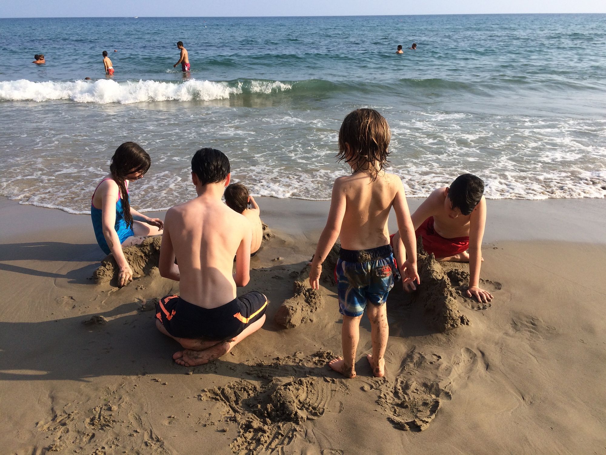
Camporosso or Ventimiglia are the closest beaches. They are about 5 miles from Apricale were recently refurbished with imported sand and rocks and joined together by a handsome promenade, thanks to a massive European grant. The nearest access is straight under the railway just to the left of the roundabout where the road from the Nervia valley meets the coast road. Coming down from Apricale turn left at the round about, then sharp right just before the petrol station. This beach can be easily accessed by bus from Apricale, as can Ventimiglia. I like to swim at the end of Ventimiglia beach just west of the Nervia river mouth where it is sandy and shelves quite gently into the sea.
There are lots of other spots to choose from. On the Italian side of the border Bordighera is probably the prettiest, this is 8 miles from Apricale. Ospidaletti just around the next corner has a sandy beach. On the French side our favourite beaches are in glamorous Menton which is about 10 miles away and accessible by bus or train. By car you can avoid the crowds and park for free by choosing the first cove just as you pass through the border post and enter the town from the Italian side. The recently completed underground parking in the town centre has lifts which bring you right onto the beach. Just follow the parking signs to find the entrance. This car park provides excellent beach access for wheelchair users. When going west we like to avoid the autostrada and take the coast road below Ventimiglia old town and the village of Latte. There are lots of little beaches and places to swim along this road, look for the parked cars. There is one narrow sandy one Callendre, which has shallow water suitable for little ones to enjoy the waves. Because of the surf this beach is crowded with teens in summer. Park on the roadside at the fortress/museum Annunciate and walk down.
In addition to its lovely beaches Menton has good gift shops and street life in the evenings with face painting, hair braiding, buskers, ice cream stalls and beach trampolines. Don’t miss the fireworks if you are here on Bastille Day!
River swimming
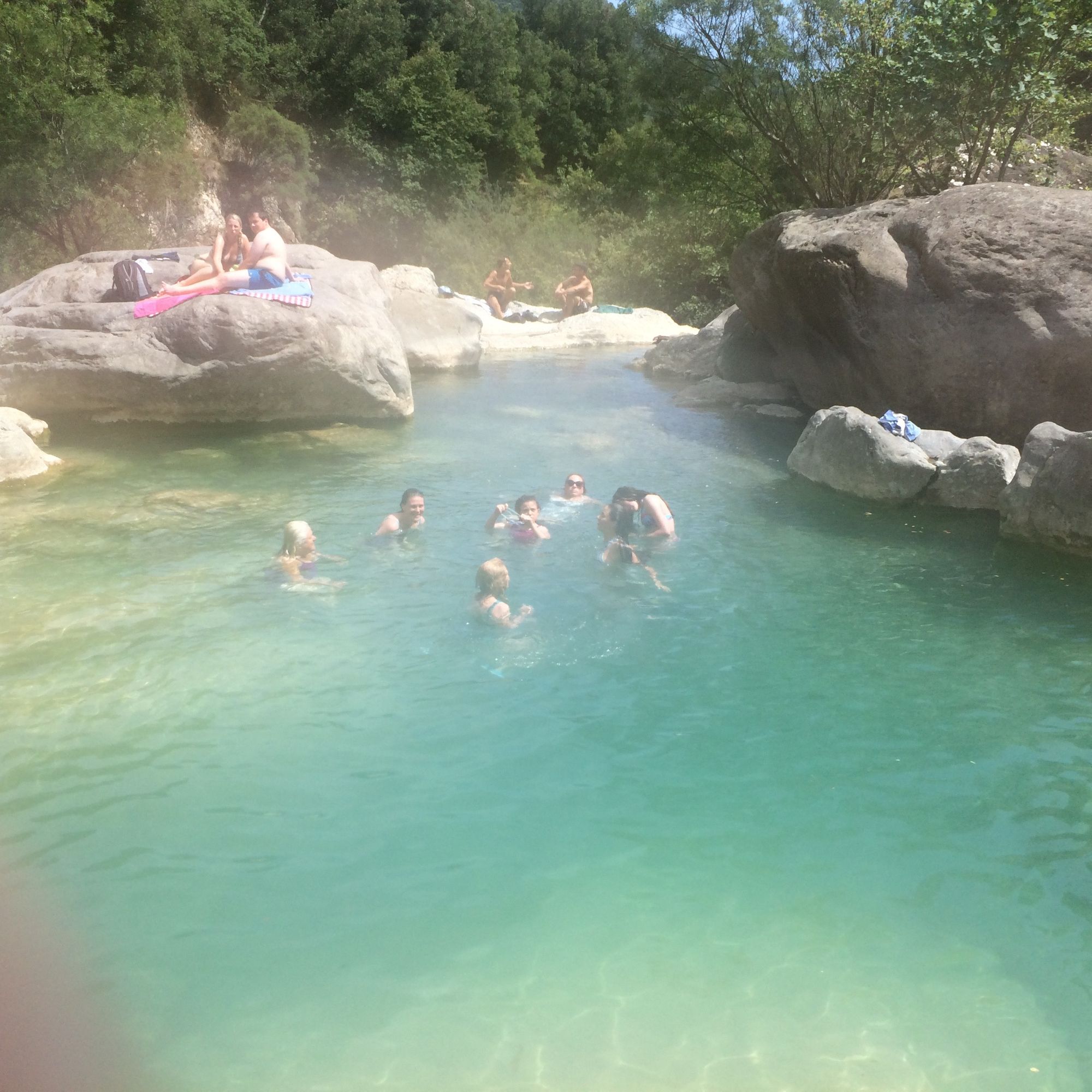
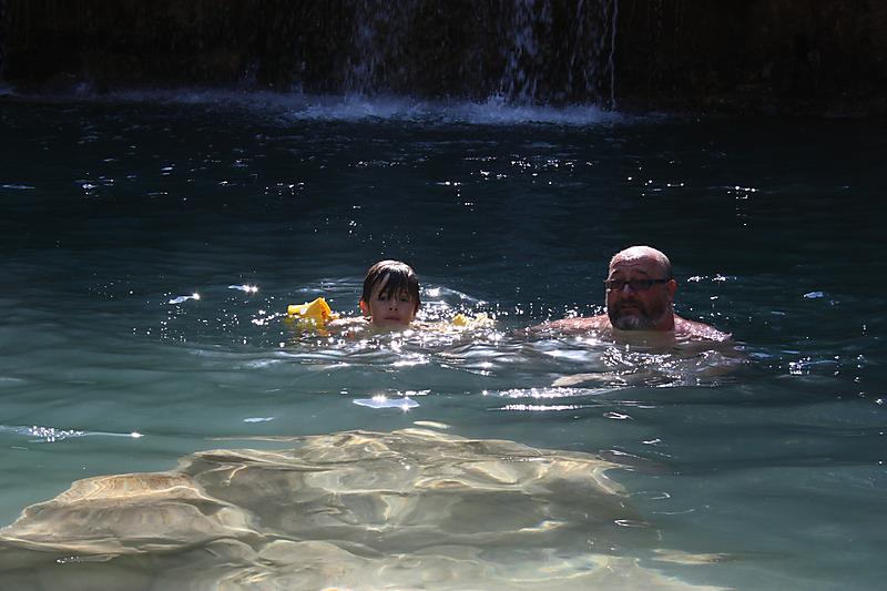
You can also swim in the lovely river pools at Rocchetta. Turn right on your way down to Dolceacqua from Apricale. Follow the footpath up stream behind the village and take your pick. There are 4 or 5 decent-sized pools, the further up you go, generally the less crowded they are. Bigger children will enjoy the rock climbing and water falls. Nice bars in the village do cool drinks, roast vegetables, salads and pizza which can be carried out to enjoy ‘a fiume’. Castel Vittorio also has pools in the river Gordale. These are very much deeper, children therefore need to be good swimmers. To find them keep straight on at the first sharp zig, zag in the road then walk and climb down to the left. More pools can be found in Pigna. Take the first turn to the left as you approach the town and drive to the end of the road where you can park.